


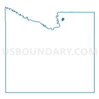
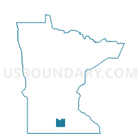
Mankato W-2 P-1, Blue Earth County, Minnesota
About
Outline

Summary
| Unique Area Identifier | 601259 |
| Name | Mankato W-2 P-1 |
| County | Blue Earth County |
| State | Minnesota |
| Area (square miles) | 0.40 |
| Land Area (square miles) | 0.40 |
| Water Area (square miles) | 0.00 |
| % of Land Area | 100.00 |
| % of Water Area | 0.00 |
| Latitude of the Internal Point | 44.20504670 |
| Longtitude of the Internal Point | -93.98068630 |
Maps

Graphs
Select a template below for downloading or customizing gragh for Mankato W-2 P-1, Blue Earth County, Minnesota


Neighbors
Neighoring Voting District (by Name) Neighboring Voting District on the Map
- Lime Twp. Voting District, Blue Earth County, MN
- Mankato Twp. Voting District, Blue Earth County, MN
- Mankato W-2 P-2, Blue Earth County, MN
Top 10 Neighboring County Subdivision (by Population) Neighboring County Subdivision on the Map
- Mankato city, Blue Earth County, MN (39,305)
- Mankato township, Blue Earth County, MN (1,969)
- Lime township, Blue Earth County, MN (1,395)